

Glaciers Facts
Glacier [\'glā–shər]
Large body of slow moving ice.
Glaciers

Have you ever seen a glacier? Unless you have travelled to polar regions or into high mountains, you may not have seen one. But glaciers have played a large role in shaping the world around us, and their impact on Earth's land, water and climate continues today. Glaciers currently cover 10% of the Earth. How did they get there? Why are they important? Let's learn more about glaciers.
What Is A Glacier?
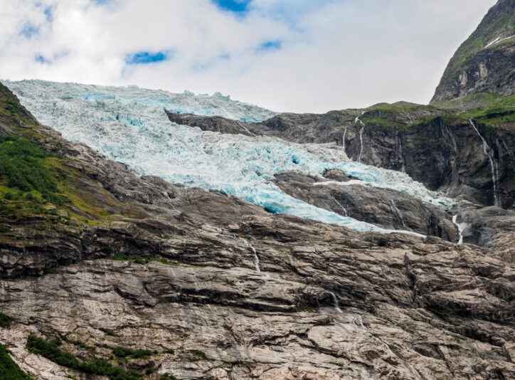
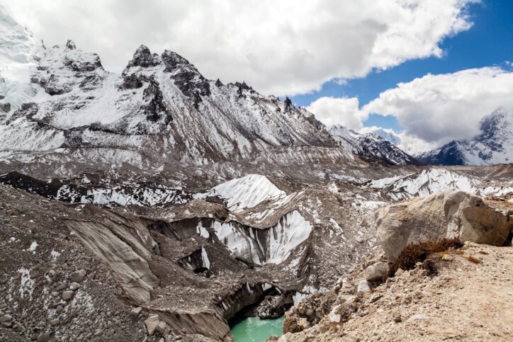
A glacier is a huge mass of ice that covers a large area of land and flows like a very slow-moving river. Glaciers are formed from expanses of fallen snow that have been compressed over time into giant sheets of ice. About 20,000 years ago, during the last Ice Age, about 32% of the earth's surface, including much of North America, Europe, and Asia, was covered by ice. Most of the earth's existing glaciers are remnants of those massive ice sheets. Today, glaciers cover 10% of the earth and store about 75% of the world's freshwater – much more than all lakes and rivers combined. Glaciers are part of the Earth's cryosphere, the Earth system that contains frozen water.
Three characteristics of all glaciers are (1) they form on land, (2) they are made of ice, and (3) they move. The Arctic region has great amounts of sea ice, but those are not glaciers because they did not originate on land. Many mountains have year-round snow fields, but they are not considered glaciers because they do not move. All glaciers require abundant snowfall in the winter and cool temperatures in the summer, so they are primarily found in polar regions or at high altitudes.
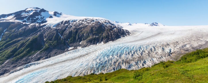
Glaciers are classified into two main groups: alpine glaciers and ice sheets. Alpine glaciers form on high mountainsides and move slowly downwards through valleys. Most alpine glaciers are found on mountains near the north or south poles, but they can be found in high mountain ranges on every continent except Australia. In the United States, glaciers can be found in seven western states, with the majority being located in Alaska.

Glaciers can be truly massive. The largest glacier on earth is the Lambert Glacier in Antarctica. This glacier measures 250 miles (400 km) long, 60 miles (100 km) wide, and 8,200 feet (2.5 km) deep. The longest glacier in the United States is Alaska's Bering Glacier at 125 miles (203 km). Glaciers contain so much water that if all glacial ice were to melt, the sea level would rise 230 feet (70 meters) worldwide.
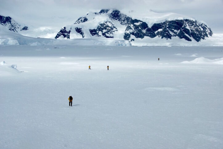
Ice sheets, also known as continental glaciers, spread out and cover areas of more than 19,000 square miles (50,000 sq. km.) Today, there are only two true continental ice sheets, one that covers Greenland and one that covers Antarctica. The Antarctic ice sheet is the largest body of ice in the world. It covers more than 5.4 million square miles (14 million sq. km) – as big as the entire United States and Mexico combined — and in some places it is 3 miles (4.8 km) thick. The Greenland ice sheet, at 656,000 square miles (1.7 million sq. km), is the second-largest block of ice on Earth. These two ice sheets contain 99% of the world's glacial ice.
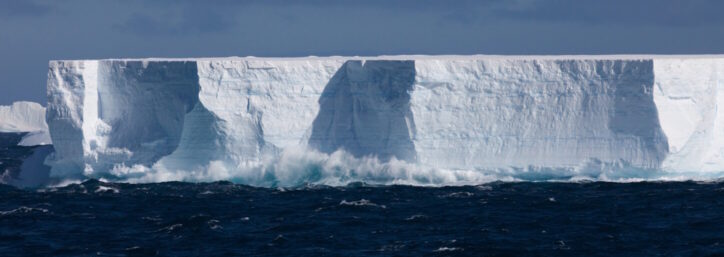
Some alpine glaciers end further down the mountain, where ice melts to form lakes and streams. Others extend to the coast. When ice sheets reach the coast and extend over the ocean, they become ice shelves. When chunks of ice break off from glaciers or ice shelves, the glacier is said to be “calving.” These floating chunks of ice that form when glaciers calve are called icebergs. Although they float in saltwater oceans, icebergs come from glaciers and are made of fresh water. Only about 10% of an iceberg can be seen above the surface of the water. Icebergs can be the size of a car or as big as 50 miles (80 km) long! From the first snowfall on a glacier to the final melting in the ocean, the life of an iceberg can span up to 3,000 years.
How Glaciers Form
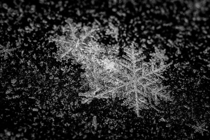
Even the biggest, most powerful glaciers began with tiny snowflakes. Glaciers form in areas where the winter snowfall doesn't melt, usually in a high mountain area or near polar regions. Glaciers start out as snowfields, expanses of year-round snow. When snow piles up year after year, the weight of the new layers of snow compresses the previous layers. The snow below, known as firn, compacts, and increases in density. Over time, the pressure of the snow and the process of melting and re-freezing turn the mass into solid ice. It's similar to taking a handful of fluffy snow and squeezing it into a hard ice ball, only on a much larger scale and over a much longer time period. The compression of the glacier may continue for hundreds of years, as more layers accumulate and more weight is added. Eventually, the glacier becomes so heavy that it starts to move.
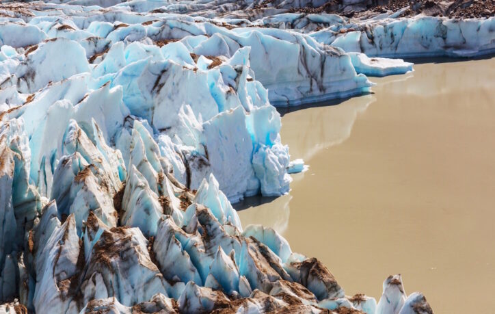
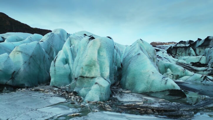
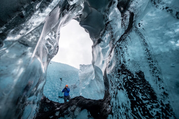
Glaciers often appear blue in color. Glacial ice is so compressed that most of the air has been forced out of it. The dense, compacted ice absorbs other colors of the light spectrum, but it reflects and scatters blue – so blue is what we see.
Parts of a Glacier
The accumulation zone refers to the part of the glacier's surface where more snow falls and is compressed each year. This is the upper region of the glacier. The ablation zone refers to the part of the glacier's surface where the loss of snow, through melting, evaporation, calving, and wind scouring, is greater than the amount accumulated. The equilibrium line is the boundary between the areas of gain and loss. This boundary can shift with the seasons, as more ablation goes on in the summer and more accumulation occurs in the winter. The head is where the glacier starts, while the terminus is the end or lowest part of the glacier. It is here that significant melting and calving can occur.

Glaciers on the Move
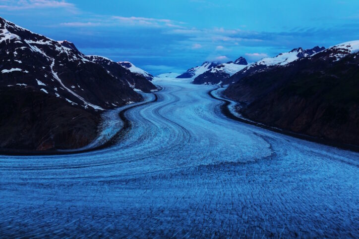
Glaciers are the largest moving objects on Earth! Glaciers are sometimes referred to as “rivers of ice.” Like rivers, they flow downhill from higher elevations to lower elevations, but they flow with frozen rather than liquid water.
Glaciers flow slowly downhill due to the forces of gravity and their own weight. They move like a very slow conveyor belt, averaging about 10 inches (25 cm) per day. But despite moving so slowly, glacial movement is powerful. As they move, glaciers crush or grind almost everything in their paths. They scrape and grind the bedrock beneath like sandpaper, and push other debris before them or alongside them.
The upper layers of the glacier move faster than the lower part. These upper sections, subject to stress produced by the moving ice, are more likely to be brittle and to form crevasses. Crevasses are giant cracks that appear on the surface of a glacier. Scientists can sometimes descend into a crevasse to observe past layers of snow and the deeper ice of the glacier.
Occasionally, movement speeds up in what is called a glacial surge. This is usually a short period of time when a glacier moves up to 100 times faster than it normally does. In 1953, the Kutiah Glacier in Pakistan moved more than 7.4 miles (12 km) in three months! Today, the Jakobshavn Glacier in Greenland is known as the fastest-moving glacier. In recent years it has been moving about 130 feet (40 meters) every day.
Sometimes people refer to a “retreating glacier.” But the glacier isn't really moving backward. It is just melting faster than it is gaining new ice. If more snow and ice are added than are lost, the glacier will advance or grow. If less snow and ice are added than are lost, the glacier will retreat or become smaller. And if the glacier is balanced with enough new snow added to replace the loss, the glacier is considered to be stable. In a stable glacier, the terminus is always in the same place. A stable glacier is still moving, but an equal amount of ice is added to and melts away from the glacier each year.
Types of Glaciers
Scientists classify glaciers according to their shape, size, and location. Ice sheets are the huge expanses of ice found in Antarctica and Greenland that cover everything in their path — valleys, mountains, and plains. Fast-moving sections of ice sheets are glaciers known as ice streams. Ice caps are similar to ice sheets but smaller. They cover areas of less than 19,000 square miles (50,000 sq. km) and are most often found in the north and south polar regions. Like ice sheets, they tend to be dome-shaped ice masses that spread out in all directions.
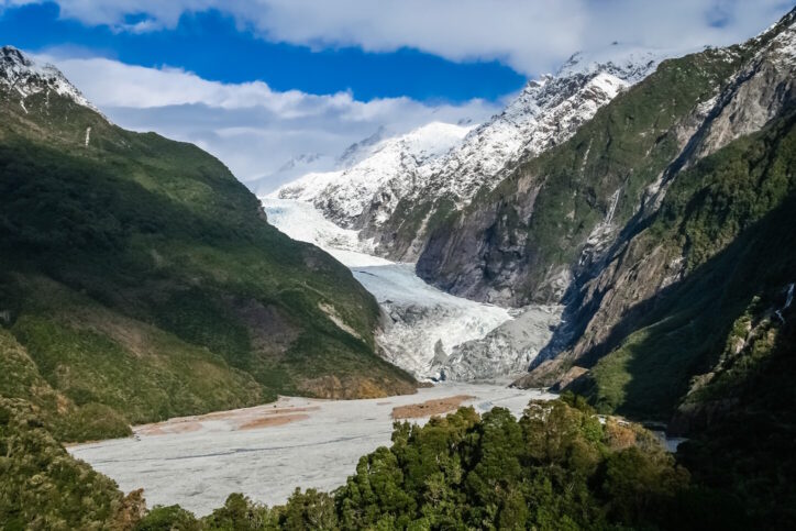
Alpine glaciers that flow down a valley are called valley glaciers. They can be up to 65 miles (100 km) long and often look like giant tongues. Cirque glaciers thought to be left over from larger valley glaciers, are small glaciers found in bowl-shaped basins on mountain slopes. Glaciers that flow down into a flat, low plain and spread out at the bottom are known as piedmont glaciers. Glaciers that flow to the coast are often called tidewater glaciers.
Shaping the Landscape: Glaciers at Work
Glaciers have played a role in shaping our planet for millions of years. Even if a glacier no longer exists, scientists can tell where a glacier has been because of its effects on the landscape. These changes take place slowly over thousands of years, but their impact on our land is significant. The process of glaciers altering the earth is known as glaciation. The work of glaciation is accomplished by erosion and deposition.
As glaciers move they transport material and carve the land, a process known as erosion. You can think of glaciers as nature's bulldozers. Like a bulldozer, a moving glacier scrapes and grinds the bedrock beneath and pushes other debris in front. Glaciers carry with them rocks and boulders that, together with the heavy ice, erode and sculpt the land underneath. In many places, scratches in the bedrock known as striations can be seen. As glaciers move downhill, they often carve out U-shaped valleys with vertical sides and a rounded floor. (This is different from V-shaped canyons carved out by rivers.) Glaciers can also form hills, deepen streambeds, and carve out basins that become lakes. The Great Lakes of the United States were created as ice sheets retreated at the end of the Ice Age.
Glaciers also create unique glacial landforms that tell the story of glaciers that once passed through an area. An arête is a sharp, narrow mountain ridge formed by two glaciers eroding the rock on opposite sides, while a horn is a steep, pyramid-shaped peak formed when multiple glaciers erode a mountaintop. A cirque is a steep-sided hollow on a mountain, carved out by long-ago glaciers.
The other way glaciers alter the land is known as deposition. Material carried and deposited by glaciers, including rocks, sand, gravel, and soil, is known as glacial till. A moraine is a mound or ridge of ground-up glacial till, usually deposited along the sides of a moving glacier (lateral moraine), in the middle where two glaciers join (medial moraine), or at the end of a glacier (terminal moraine.) Sometimes glaciers crush rocks into a fine powder known as rock flour, while in other cases, huge boulders known as glacial erratics are deposited far from their original location and scattered across the landscape. All of these features are the results of glacial erosion and deposition. Learn more about glacial landforms.
One of the biggest ways a glacier has shaped the planet can be seen at the South Pole. Due to the weight of the Antarctic ice sheet, the land is compressed and the earth slightly flattened in the south polar region. In some parts of Antarctica, the land actually lies below sea level, due to the weight of the ice.
Glaciers and Our Warming Planet

Glaciers are very important to Earth's systems and people. Because snow and ice reflect most of the sun's radiation back into space, glaciers help to regulate the planet's temperature. Glacial till provides fertile soil for growing crops. The most important resource provided by glaciers is the storage of frozen fresh water. Since only 2.5% of the water on Earth is freshwater, and freshwater is essential to support life, every bit is important. Many communities depend on rivers that are fed by the melting ice of glaciers. For example, meltwater from the glaciers of the Himalayan mountains drains into river basins that provide water for more than one billion people. In some places, glacial meltwater is used by people to irrigate crops and to generate hydroelectric power. In addition, the runoff from glaciers in mountain environments contributes to the stream habitat needed by many species of fish, insects, and plant life.
Our earth is currently getting warmer. Temperatures are rising faster than they have in the past. As our planet gets warmer, glaciers around the world reflect this global climate change. Comparing photographs of glaciers over the past 100 years reveal that many are shrinking rapidly. Scientists predict that many alpine glaciers will soon disappear completely.
Why does it matter that glaciers are shrinking? One reason is that as light-colored ice and snow melts, less of the sun's energy is reflected back out into space and more heat is absorbed by the land and water, causing temperatures on Earth to rise. Another reason for concern is that the loss of glacial ice reduces the fresh water available to plants, animals, and humans on land. In addition, melting ice sheets contribute to rising sea levels. If sea levels rise, coastal habitats and cities are put at risk of being flooded. In addition, adding large amounts of freshwater to the ocean causes changes in marine ecosystems and ocean currents. Disruptions in ocean circulation patterns can affect the weather on land as well. Glacial ice serves many functions that affect Earth's systems and contribute to the health of our planet.
Learn more about the effects of climate change at Science Trek's Climate site.
Glaciologists
Scientists who study glaciers are called glaciologists. They spot clues in the landscape that tell the story of glacial action in the past, thus increasing our knowledge of the Ice Age and geologic processes. They study current glaciers to learn more about their continued effects on the planet. They study the ways that glaciers are melting, fracturing, and moving, and what those changes mean for our earth in the future. They analyze how much water enters the oceans from melting glaciers.
Another reason glaciers are important to science is that glacial ice, particularly in ice sheets, can be hundreds of thousands of years old. Trapped air from deep within the ice contains a sample of the past atmosphere, including gases, dust, ash, and pollen. Scientists can extract ice cores and study the frozen ice to learn about what the climate was like on Earth long ago.

NASA satellites, orbiting above the earth, also study glaciers. Data collected from satellites allows scientists to learn about glaciers in areas that are too isolated for in-person surveys. Scientists analyze satellite imagery to study glacial movement and changes. Data from satellites also helps scientists understand the relationship between melting glaciers and sea level rise. NASA instruments have even taken pictures of glaciers on Mars!
There is still much to learn about the power of glaciers both in the past and in the present. They are not only beautiful and majestic, but also very important to our planet. So keep your eye on glaciers!
Fun Links
Investigate 10 Interesting Things About Glaciers with fun animations from NASA's Climate Kids.
Explore glacier facts and photos with National Geographic Kids.
Learn more about glaciers, ice fields, and icebergs at the Learning Zone.
Water Science School, a learning site for young people from the United States Geological Survey (USGS), has a section called Glaciers and Icecaps for you to explore. You may also want to take a look at Facts and Myths About Glaciers, Glaciers and the Water Cycle, and Answers to your Questions.
Check out the glacier interactive from DK Find Out. As you explore the site, you'll learn more about how glaciers form, how glaciers change the land, and how various types of glaciers are different.
At Brittanica Kids, read about glaciers, watch a glacier calving, and listen to a narrated slideshow. There is also a version of this page for middle-school ages.
Where do glaciers still exist? Are there ancient viruses trapped in glaciers? Find answers to your questions and ideas for hands-on projects at Wonderopolis.
Rock Paper Glacier! is a site for kids that invites you to consider what it would be like to actually be on a glacier.
Learn more about glaciers and see an awesome collection of glacier photos at Kiddle Encyclopedia's Glacier Facts for Kids.
These four-minute glacier videos are fun to watch and are full of glacier surprises: How Glaciers Change the World! and All About Glaciers For Kids.
Alaska is home to most of the glaciers in the United States. In fact, glaciers are the #1 tourist attraction in Alaska! Find out about Glaciers and Climate Change from Alaska's Kids Rock site, and from Alaska Kids: Glaciers.
See amazing before-and-after photos showing how glaciers have changed over the past century with these interactives from PBS LearningMedia and the National Park Service.
Do you think you'd like to be a glaciologist someday? Learn about fascinating work of a USGS glaciologist who studies particles in glaciers and satellite data and a National Geographic glaciologist who studies glaciers in Iceland. Then see how students in Alaska are involved in real glacier research as they survey a glacier near their home.